Salvation Mountain in 360°

View on Google Maps Street View

A year ago I blogged about my New Year’s goal to develop my chops in 360° photography. To that end, throughout the 2011 I explored and photographed spaces that artist’s work in and/or find inspirational.

This brought me to Salvation Mountain on Easter Sunday where not only did I meet the artist Leonard Knight (see original post) but also had a star sighting: Sean Penn and his gal pal Scarlett Johanssen. Knight appeared as a cameo in the film “Into the Wild” (2007) that was directed by Penn. It would appear that since then they’ve remained friends.

When in early December Knight was placed in a home after being diagnosed with dementia, I became concerned about the survival of his life’s work.  In my humble opinion, without the artist there to maintain it, it wouldn’t be long before the mountain suffers from either erosion or vandalism or both.

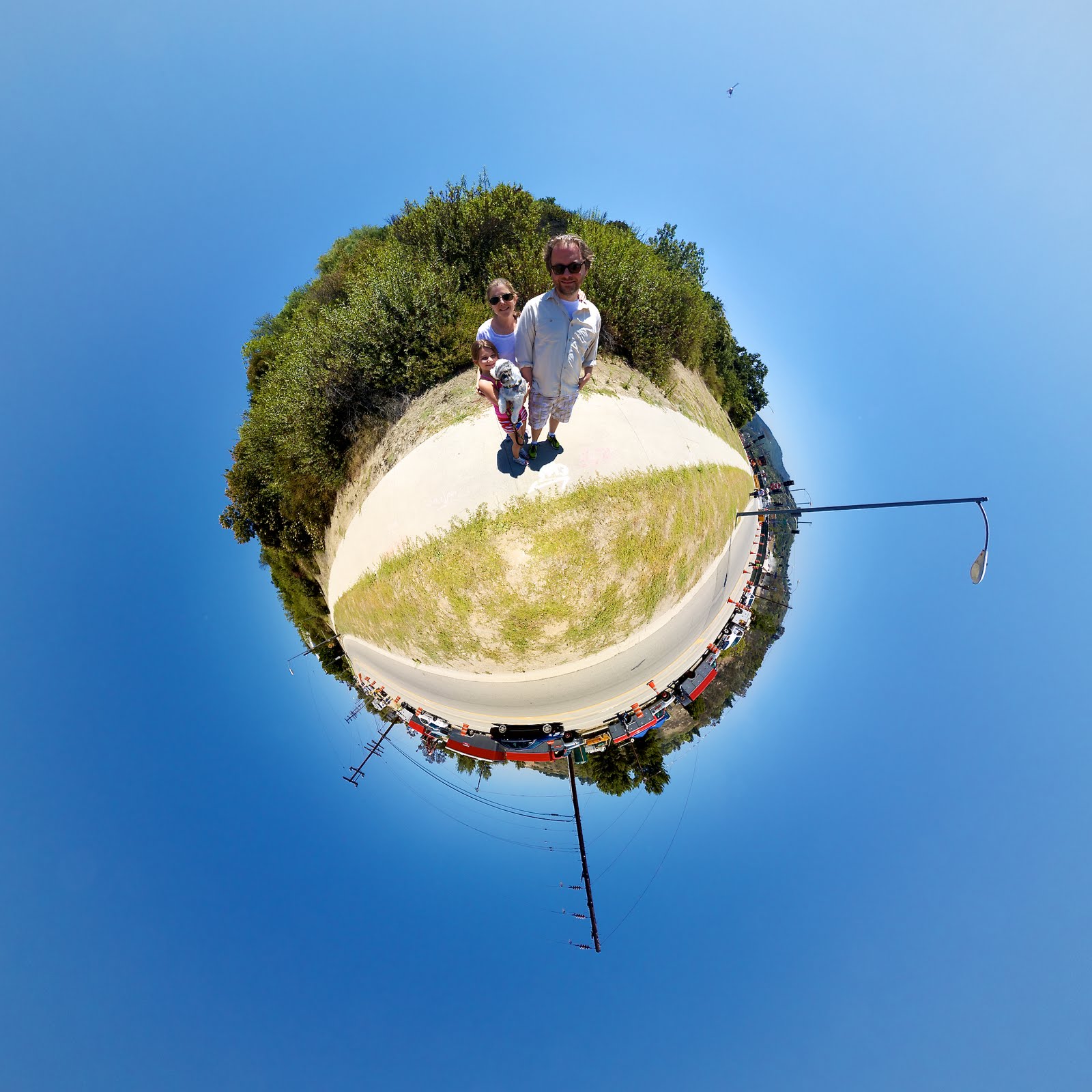
Salvation Mountain – “Little Planet” projection

So I made plans to camp at Salvation Mountain for New Years and take some panorama photos for posterity. The first time I came to visit the weather was warm but blustery winds whirled around the mountain which limited my ability to interior shots only.

This time, however,  the weather conditions were more favorable: the air was calm and still which enabled me to get a series of exterior shots that I’ve posted below.

Salvation Mountain gives curb appeal to the community of people who live in what’s called Slab City, an abandoned Marine base in the Salton Sea that’s been overtaken by squatters for the past 50 years or so. You could say the mountain is the crown jewel of the slabs.

Recently there’s been a lot of press about Slab City* that’s mostly tied to Knight’s health reports and the fate of Salvation Mountain. This has caught the attention of many journalists (of which I met several on this recent trip) that have discovered that Slab City’s inhabitants to be rich with human interest stories about outsider artists as well as survivors of the Econopocalypse.

I should say that “slabbers“, as the locals like to refer themselves to, consists of folks living on the edge: a weird hybrid of retired fixed income senior citizens and wealthy snowbirds, homeless vagabonds, itinerant Canadians (!), dirty hippies, children of the Rainbow Family and binky sucking candy ravers, not to mention runaways, alcoholics, tweekers and dropouts.

It’s not exactly a tourist destination to go to Slab City. It’s not even remotely like a family vacation at Disneyland or even Burning Man.  No, Slab City is rough yet some inhabitants have brought their families there presumably because they have no place else to go.  A visit to the slabs is like entering the world of Mad Max where all the perceived danger is real. It’s no place for kids. That said, most of the locals I met were incredibly kind, genuine and authentic.  I even met a bunch of out-of-towners like myself including a slew of hipsters from San Francisco, a contingent of Tucsonian students, and some German and Australian tourists. Of course, academia also represented: I met a sociolologist from Stanford documenting the slabbers and their urban tribal community.

While I befriended many slabbers that I consider to be the salt of the earth, I also found that a few of Slab City’s inhabitants — to quote Obi Wan Kenobi — can be described as wretched and well, downright scummy. One must be cautious when visiting this place.  If you’re thinking of visiting put your trust to the tender mercies of a man named James, a long-time slabber with the world’s smartest and cutest dog called “Spider Monkey” and tell him I sent you.

If you prefer to visit the slabs through the magic of technology, you can catch James tonight at 10pm on the History Channel: Corey’s Big Play. (2012). https://www.history.com/shows/pawn-stars/episodes/current-season.  And you can always virtually visit Salvation Mountain through the series of 360° panoramas I took by clicking on the images below:


Entrance to Salvation Mountain


Parking lot of Salvation Mountain


Leonard Knight’s “Yellow Brick Road”


The Gates of Love at Salvation Mountain


North side of Salvation Mountain


Salvation Mountain from the road


Interior, Salvation Mountain


* Slab City: Last free place in America? Imperial Valley Press, December 31, 2011
All directions point to East Jesus, Imperial Valley Press, December 31, 2011
Hard Times on Salvation Mountain, KCET, December 20, 2011
The Future Of Salvation Mountain Uncertain, KPBS, December 20, 2011
A 24 Hour Visit To Slab City…, Seattle Post Intelligencer, December 20, 2011
Living off the grid in Slab City, Los Angeles Times, December 19, 2011
Slab City, a trailer park utopia, thrives in remote desert – Los Angeles Times – December 17, 2011
 “Slab City” a desert haven for recession’s victims, CBS News – December 14, 2011


An Update on Leonard Knight, Creator of Salvation Mountain

View on Google Maps Street View


This past Easter I went to visit Leonard Knight, 80, the creator of “Salvation Mountain” an on-going art installation near Slab City in the Salton Sea, California. Just last week, Knight was hospitalized. According to reports, he was suffering from cognitive issues. He was placed in observation for 72 hours and then subsequently released to a long-term care facility with a diagnosis of dementia.

Salvation Mountain is significant not only as a major American folk art installation but also because of Leonard’s heartfelt and simple message that God is love. He spent over thirty years building the mountain to convey that message and during that time he personally told each and every visitor the same thing.

If Leonard’s friendship, art or message has touched your life, won’t you take a moment to send him a note of gratitude, love and support?  You can send him a card or letter to:

Leonard Knight c/o
Eldorado Care Center
510 E. Washington

El Cajon, CA 92020

More 360° Panorama Photos from the Epicenter of Carmageddon, July 2011

Click to embiggen

Last Saturday night’s concert of the Monkees at the Greek was awesome, especially after coming off the excitement of being on the 405 freeway when it was closed off. As promised, here are some more panorama photos taken at the epicenter of Carmageddon.

On the morning of July 16th, I decided to risk being stuck in what was being predicted to be LA’s worst gridlock nightmare. My plan was to hike up to Mulholland from the valley-side of Sepulveda in an attempt to get some panoramas. But I wanted to see how far up the side of hill I could drive before I hit traffic and then I would hoof it from there.

Photo: Malingering

Interestingly, as I set out on my daring plan the streets were really calm and practically empty. At Sepulveda and Burbank I noticed a gloved traffic cop standing on the corner looking bored. Then at Sepulveda and Magnolia I noticed another traffic cop and several more at the intersection of Ventura Boulevard. This went on for every traffic light as I headed up Sepulveda towards Mulholland and it didn’t take long before I was driving pass the Skirball Center and pass the demolition site as well.

Photo: Malingering

I tried to find a place to park but there was none to be found. I ended up turning around and parking north of Mulholland on a residential street and then walking back to the site. Along the way I met several happy spectators on foot including another blogger who had run all the way from Santa Monica with his Flip video camera interviewing people. I asked him what the name of his blog was but he wouldn’t tell me. WTH? I guess he was afraid I would cyberstalk him! Whatev. I’m glad I declined to be interviewed.

Anyway, I even met a man that rode his bike from Venice Beach. He was repairing what he said was his third flat tire and he was concerned about making it back home with no tire to spare. But I reminded him that MTA was offering free bus rides for Carmageddon weekend and he brightened at the idea of a back-up plan. It’s worth mentioning that the Metro Rapid 761 drove by as we were talking and there was nobody on it!

As I approached the Mulholland Bridge, the site was fenced off and the LAPD were everywhere. I thought for sure I would be told to turn back. But to my surprise they were very friendly and encouraged me to have a look around but to stay on the sidewalk and observe traffic lights.

Above is my second panorama taken on the tarmac of the 405 freeway. I’ve oriented the image to open up looking southbound towards the Skirball Bridge that’s currently under construction. Beyond the bridge are concrete barricades. If you scroll your mouse and do a complete 180 degree turn, you’ll be facing towards the Mulholland Bridge. Due to the nature of panorama photography, it appears tiny and way off in the distance but it really wasn’t that far. However, for safety reasons this was about as close as the press was allowed. Unfortunately you can’t really see the work crews with industrial machinery “woodpecking” away at the bridge bit by bit to bring it down.

Photo: Anthony Citrano

I have to say: it was pretty epic to be standing on the closed off freeway with nothing but what sounded like jackhammers taking down the bridge as well as the sound of helicopters of overhead.

Some folks want to know how I got down to the tarmac. The story is pretty cool, IMHO. Not too far from where all the action was happening was the media village that was chockablock with news crews and satellite dishes. Most of them were just hanging around. One guy even fell asleep upright in his folding chair while his buddy was mischievously taking his photo.

I started talking to some reporters when suddenly the press was invited to walk down the freeway ramp and report from there. Since I didn’t have a “press pass” or any sort of official badge, I was asked by an LAPD officer what news organization I was with. I told him I was a blogger and that was that. Away I went along with the press to photograph this historic local event.

While on the freeway, I met a news crew from Time Warner and happily took photos of them with their iPhone after they had just captured their story. I also talked to a camera operator who told me he was 17 years old when the freeway opened and that he was one of the first to drive it as he flew down the hillside towards the San Fernando Valley on his motorcycle breaking the speed limit. He said at the time it was pretty cool but that now — 51 years later — to be able to walk on the very same spot was pretty amazing, too.

Below is the last of my panorama photos from the epicenter of Carmageddon. As I’ve mentioned, for safety reasons, no one but the demolition crew was allowed close to the Mulholland Bridge. While it was pretty darn amazing to be down on the tarmac when the freeway was closed off, the viewpoint wasn’t too great. In an attempt to find an optimum view I walked up Skirball Drive to Mulholland to where the road turns into Mulholland Bridge.

Click to embiggen

Unfortunately it was all fenced off and it was difficult to see much or snap a worthwhile image. But while I was there, I ran into a long time client. She lives about a mile east on Mulholland and she was there with her family to check out the momentous occasion. So I took the opportunity to capture the moment for them. Off in the distance on camera right beneath the green traffic lights you can see some of the demolition taking place. If you can imagine, where the dust clouds are coming from below about 100′ is the 405 freeway. Incidently, the dust was being watered down by a long hose which is not really clear in this image.


While I had a great weekend not only for the fact that I got to take these photos and see the Monkees in concert, the apocalyptic reality of “Carmageddon” itself was about as underwhelming as the Y2K bug. On the news this morning Los Angeles County Supervisor Zev Yaroslavsky was quoted as saying “Carmageddon, shmarmageddon!” and suggested the city make the event an annual holiday. While I don’t think Los Angelenos will be duped again to the media frenzy and fear tactics that went into play for the second half of the Mulholland Bridge demolition slated for next year, I do hope that maybe the citizenry can join together with local government to make this unique experience happen again soon.

360° PANORAMA OF CARMAGEDDON! THE 405 FREEWAY CLOSURE @ MULHOLLAND


This image is my first in a series of the epic Carmageddon weekend in Los Angeles. More to follow but for right now I’m off to see the Monkees (hey hey!) perform at the Greek.

Please excuse the stitching errors but this pano is a rush to publish. If you’re from Los Angeles I’d love to hear how your weekend is going.

If you’re viewing this image from the RSS feed, be sure to click through to the site of origin. Most 360° panoramic vr photographs that are embedded in my blog do not show up correctly in my feed due to permissions settings.

If you are unable to see the described panoramic image click here to view it on the site in which it is hosted.

I’d love it if you would click through on the link to rate this image. Pretty please???

Interior of a 1937 Pierce Arrow Trailer at the Nethercutt Museum in Sylmar, California


1937 Pierce Arrow Trailer Interior at The Nethercutt Museum in Sylmar

In memory of my father and grandfather, for Father’s Day this weekend I visited the Nethercutt Museum in Sylmar, California, to have a look at some of the world’s greatest antique, vintage, classic and special interest automobiles on display.

Growing up dear old dad drove a black convertible 1955 Cadillac El Dorado which was his daily driver. Occasionally on the weekends he’d take out the blue hard top 1955 Coupe de Ville for a spin. In the late eighties, he traded them both in for a gold convertible 1971 Cadillac Ed Dorado which he also commuted with daily.

But there were more than Cadillacs in our two car garage. We also owned a red 1945 Packard that my dad would cruise Van Nuys Boulevard on Wednesday nights with the family.  And then there was our beloved blue 1955 Chevy Bel Air which was my mom’s daily driver that she drove well into the nineties.

Touring the Nethercutt by myself made me nostalgic. I didn’t have my grandfather around to talk stories about the past and I didn’t have my dad to share the history of each vehicle. I miss them both.

On my own I explored the fully restored 1937 Pierce Arrow trailer and tow car simply because I could step inside and capture this 360° image.

What’s great about visiting the Nethercutt is that it is completely free. Be advised that the Museum is a self-guided tour that is available on a walk-in basis however next door, the Collection (which in addition to classic cars features rare collectibles ranging from mechanical musical instruments and antique furniture) is only available to view by guided tour so make a reservation in advance.

More information at NethercuttCollection.org

Something to do in Los Angeles This Weekend: Walking Tour of Thai Town Street Art Graffiti Murals


View Walking Tour of Thai Town Graffiti Street Art Murals in a larger map

I’m taking off for the Memorial Day weekend, leaving behind my house-sitting stint and the world’s sweetest kitty so I’ve put together a map of a walking tour (see above) of the street art murals in the Thai Town area that I’ve been blogging about these past few days.

Some of the works from graffiti artists you’ll see on this tour: RETNA, Miles “Mac” MacGregor, LA Mural Front, Dabs Myla, Desire Obtain Cherish Street Team and SEVER(MSK AWR T7L LOSS PREVENTION) and OZER(LTS T7L).

Click on the map pin to view an image to help you identify the piece. You can even click on the image in the popup to view more information or even perhaps an interactive panorama.

There’s way more to see in the area. But if you head west towards Hollywood and Highland, you’ll find this piece from Banksy Mr. Brainwash (left).

If you know of a location, please help me stick a pin in this collaborative map.  Note: I reserve the right to edit the map pins if the locations don’t relate to street and graffiti art.

It won’t take you more than 30 minutes to see them all but you may want to grab a cup of coffee or smoothie at the nearby Casablanca Coffee Lounge in which case add some more time to your tour.

Have a great weekend!

 Click through below for 360 interactive images:
“Venus” Mural by Desire Obtain Cherish Street Team

On the opposite wall is a piece by the LA Mural Front.
Mural by Dabs Myla

Super Smooth by Dabs Myla

La Reina de Thai Town

A collaborative mural by Retna & Miles “Mac” MacGregor
Violence Solves Nothing by the Seventh Letter

By SEVER (MSK AWR T7L LOSS PREVENTION) and OZER(LTS T7L)
Kannon / Kuan Yin

A collaborative mural by Retna & Miles “Mac” MacGregor

“La Reina de Thai Town” and “Kannon / Kuan Yin” – Two Murals by RETNA and Mac

“Kannon / Kuan Yin” can be found at the intersection of Hollywood and Western across the street from the Metro station

Success happens overnight for some people but for graffiti artist turned gallery artist, RETNA’s breakout success is a long time in the making. Last week, RETNA unveiled a unique work of art on the tail of one of VistaJet’s Global Express XRS aircraft during EBACE 2011 in Geneva. This week RETNA was featured in the new documentary “OUTSIDE IN: The Story of Art in the Streets” that premiered yesterday at the Egyptian Theatre in Hollywood.

However, RETNA’s been collaborating with fellow street artist Miles “Mac” MacGregor for several years now and many of the murals they’ve produced together have become local landmarks, two of which happen to be within very close proximity to the place where I’m house-sitting.

Featured here “Kannon / Kuan Yin” (above) and “La Reina de Thai Town” (below) were created in 2007 and 2010 respectively. I’ll be posting a map of the street art of Thai Town along with some additional fantastic murals soon.

“La Reina de Thai Town” is situated just south of Hollywood Boulevard on Wilton

Desire Obtain Cherish versus Stella Artois on Hollywood Boulevard

I’m house-sitting in Thai Town, an area on Hollywood Boulevard roughly between Wilton and Normandie just off the 101 freeway.  In addition to featuring some of the best Thai restaurants in Hollywood, the hood  also plays host to a dream team lineup of some of the city’s finest street artists including the LA Mural Front, Miles “Mac” MacGregor, RETNA and most recently the street team of Desire Obtain Cherish.

When not overtaking the billboard of a Stella Artois ad over Torung Restaurant (right, May 2011), Desire Obtain Cherish have also blessed the alley way near Mel Pierce Camera with a fleeting ephemeral vision they call “Venus” that I captured in 360° (above).

Join me over the next few days as I’ll be sharing with you some more works in this fascinating neighborhood street gallery.

Salvation Mountain: Leonard Knight’s Interactive Vision in the Desert

View on Google Maps Street View


Leonard Knight, 79, has been building “Salvation Mountain” an on-going art installation near Slab City in the Salton Sea, California, for the past 27 years. Its sole purpose is to convey the simple message “God is love.”

Because of Knight’s dedication, it seemed fitting to see Salvation Mountain on Easter.  So last Sunday along with my sister we set out for a visit, and while we were there, we had an opportunity to meet the artist.  Knight is a sweet, kind soul as evidenced in the video clip below. He has only recently returned to the mountain after being hospitalized for heart complications about six weeks ago. Despite his weakened condition, the artist remains cheerful and vibrant sharing his message and giving gifts of postcards, stickers and a DVD featuring a documentary about his work to all who come to visit.

The mountain was fabricated from an adobe mixture that Knight mixes himself using dirt from the desert floor and straw.  The structure is then lovingly lavished with color using thousands of gallons of paint.

(Above) Artist Leonard Knight was featured in the in the 2009 film Into The Wild directed by Sean Penn who happened to be visiting the same day I was accompanied by his gal pal Scarlett Johansson.
 

Whether it’s Easter Sunday or not, anytime is a great time to visit Salvation Mountain but more so now while Knight is still alive and kickin’.  According to his friend Kevin Eubanks, due to his health Knight will no longer be sleeping in his truck near the mountain at night but instead staying at a house nearby in Niland with visits to the site during the day.  You can keep up with the latest developments at Salvation Mountain’s Facebook page.

Queen Califia’s Magical Circle


This is my latest 360° panoramic image from Queen Califia’s Magical Circle, a mosaic sculpture garden by Niki de Saint Phalle located in Escondido, CA. The garden consists of nine large-scale installations including a circular “snake” wall with a labyrinthine entrance into the confines of the circle.

Eight large totems of mythical monsters and deities surround the main piece of Queen Califia standing upon the Eagle Throne. There used to be a gold-egg shaped fountain underneath the eagle that referred to Queen Califia’s magical reign over oceans and also symbolized the cycle of birth, death, and transformation.  It is faced with handmade gold leaf sandwich glass that was controlled by a solar pump.

Upon my latest visit the Egg Fountain had been removed, due probably to abuse since this beloved park is overrun with children and adults climbing and scaling these fragile mosaic pieces. On the one hand, you can’t blame folks for stomping all over the installations as they appear to invite interaction with their colorful textures and shapes. However, I’m afraid that should this rough interaction continue with the pieces not maintained they too will suffer removal like the Egg Fountain.

The Niki Endowment Fund was established to enable the city of Escondido’s school children an opportunity to visit the garden. It pays for transportation costs of docent lead classes to visit the site. For more information about the fund and how to contribute call 760-839-4331.